America's Greatest Road Trip: The 10-Day National Parks Loop That Will Rewire Your Brain
Destination: United States
Category: Destination Guides
America's Greatest Road Trip: The 10-Day National Parks Loop That Will Rewire Your Brain
There is a moment — and every person who has done this drive knows exactly the one — where you crest a ridge somewhere in southern Utah and the world simply stops making sense. The scale is wrong. The colors are wrong. The silence is wrong, in the best possible way. You pull over not because you planned to, but because your hands just do it. You get out of the car and stand there like an idiot with your mouth open, and you think: I live in the same country as this?
That's the American West. And if you haven't done this road trip yet, you are sitting on one of the greatest adventures of your life.
This isn't a listicle of pretty photos. This is the real itinerary — the one that hits the parks that will genuinely change you, in the order that makes logistical sense, with the specific details that separate a good trip from an unforgettable one. Ten days. Five parks. One loop that starts and ends in Las Vegas, covers roughly 1,400 miles, and earns its place as the greatest road trip on American soil.
Why This Loop, Why Now
The American West has been drawing travelers since John Muir first put words to what he saw in Yosemite in the 1870s. But the Southwest loop — Las Vegas to Zion to Bryce Canyon to Arches to Canyonlands, with a detour through Capitol Reef if you're ambitious — has quietly become the bucket-list road trip for a new generation of travelers who want something more than a beach chair.
The numbers back it up. Zion National Park alone welcomed over 4.5 million visitors in 2023, making it the third most-visited national park in the country. Arches sees over 1.8 million. These aren't hidden gems anymore — but they remain genuinely, profoundly spectacular, and with the right planning, you can still find yourself standing at the edge of Delicate Arch at sunrise with almost nobody else around.
The key word is planning. This trip rewards preparation and absolutely punishes improvisation. Book accommodation six months out for peak season (April–June and September–October). Secure your timed entry permits the moment they open. Start every single day before 7 AM. Do those three things and this trip will be the best two weeks of your year.
If you want a complete day-by-day breakdown of the full loop, our Utah Mighty Five 10-Day Road Trip guide covers every driving segment, campsite, and permit in detail.
The Route at a Glance
Las Vegas → Zion National Park → Bryce Canyon National Park → Grand Staircase-Escalante → Capitol Reef National Park → Canyonlands National Park → Arches National Park → Moab → Las Vegas
Total driving: approximately 1,400 miles
Ideal season: mid-March to late May, or mid-September to early November
Base budget: $3,500–$5,500 for two (flights, lodging, food, fuel, park passes)
The America the Beautiful Annual Pass ($80) covers entry to all five parks and pays for itself on day one. Buy it before you leave home.
Flying in and out of Las Vegas? Our Las Vegas 4-day itinerary is worth bookmarking — most people tack on a night or two at the start or end of this trip, and Vegas rewards the effort.
Day 1–2: Zion National Park — Where the Trip Begins and Your Legs End
Fly into Las Vegas, pick up your rental car, and drive the 2.5 hours northeast to Springdale, Utah — the small town that sits at Zion's south entrance and has quietly become one of the best basecamp towns in the American West. Check in the night before your first full park day. The Driftwood Lodge has rooms with direct canyon views and a pool that feels like a reward you haven't earned yet. Cable Mountain Lodge is a step up in price and a significant step up in ambiance.
Zion operates on a mandatory shuttle system from spring through fall, which means private vehicles can't drive the main canyon road. This is a feature, not a bug. The shuttle runs every few minutes and the lack of car noise makes the canyon feel genuinely wild.
The Narrows is the hike that defines Zion for most people, and the hype is entirely justified. You walk up the Virgin River — literally wading through the water between walls of Navajo sandstone that rise 1,000 feet on either side and narrow to 20 feet across. The light that filters down in the late morning turns the canyon walls amber and gold. Rent neoprene socks and water shoes from Zion Outfitter in Springdale the night before — your feet will thank you. Start by 7 AM to beat the crowds and get the best light.
Angels Landing requires a permit (lottery system, apply at recreation.gov 30 days out) and deserves every word of its reputation. The final half-mile involves chains bolted into sheer rock face, a 1,488-foot drop on either side, and a view from the top that makes you feel like you've earned something. If the permit lottery doesn't go your way, the West Rim Trail offers the same views from a different angle with no permit required and a fraction of the crowds.
One thing most first-timers miss: Emerald Pools Trail in the late afternoon, when the crowds thin and the light goes golden. The upper pool sits in a natural amphitheater with a waterfall that drops directly onto the trail. It's a 3-mile round trip and one of the most quietly beautiful walks in the park.
Two days barely scratches the surface here. If Zion is calling you for a longer stay, our 5-day Zion adventure guide and couples-focused 4-day Zion itinerary go deep on every trail, viewpoint, and hidden corner worth knowing.
Day 3: Bryce Canyon — The Park That Looks Like Another Planet
Drive the 86 miles northeast from Springdale to Bryce Canyon. It takes about 1.5 hours and the road itself is worth the drive — you climb from red rock desert into ponderosa pine forest and arrive at an elevation of 8,000 feet where the air is noticeably thinner and cooler.
Bryce Canyon is not technically a canyon. It's an amphitheater — a series of natural bowls carved by frost, rain, and time into thousands of hoodoos: tall, thin spires of orange, red, and white limestone that look like they were placed there by a civilization that no longer exists. The largest concentration of hoodoos on Earth is right here, in a park that most people spend only a single day in. That's enough time to see it. It's not enough time to feel it.
Sunrise Point at actual sunrise is the non-negotiable. Get there 20 minutes before the sun clears the horizon. The hoodoos glow from the inside — they turn from grey to pink to deep orange in the space of about ten minutes, and the shadows between them shift in real time. It is one of the most photogenic 30 minutes you will ever experience. Inspiration Point, just a short drive south, is slightly less crowded and arguably more dramatic.
For the hike, do the Navajo Loop and Queen's Garden Trail combination (3 miles, moderate). You descend into the amphitheater on the Navajo Loop — through Wall Street, a slot canyon so narrow you have to turn sideways — and return via Queen's Garden, which winds through the hoodoos at eye level. The perspective from inside the amphitheater is completely different from the rim. Do both.
One insider detail that most people skip: Fairyland Point, about a mile north of the main visitor center, is the least-visited viewpoint in the park and has some of the most dramatic hoodoo formations. Almost nobody goes there at sunrise. Almost nobody goes there at all.
Want to spend more time here? Our 4-day Bryce Canyon adventure guide covers the park in full, including the best stargazing spots — Bryce sits at 8,000 feet with minimal light pollution and some of the darkest skies in the lower 48.
Day 4: The Drive Through Grand Staircase-Escalante
This is the day most itineraries skip and the day that separates a good road trip from a great one.
The 124-mile drive from Bryce Canyon to Capitol Reef on Highway 12 is consistently ranked among the most scenic drives in the United States, and it earns that ranking. The road passes through Grand Staircase-Escalante National Monument — 1.9 million acres of canyons, mesas, and slot canyons that see a fraction of the visitors that the named parks do.
Stop at Head of the Rocks Overlook for a view that stretches 100 miles in every direction. Stop at Calf Creek Falls if you have the energy for a 6-mile round-trip hike to a 126-foot waterfall hidden in a canyon that looks like it belongs in a different country. Stop at the tiny town of Boulder for lunch at Hell's Backbone Grill, which has been called one of the best restaurants in Utah and operates on a farm-to-table philosophy that would be impressive in a major city, let alone a town of 200 people.
This is a driving day, but drive slowly. The road narrows to a single lane at points, climbs to 9,600 feet, and offers views that will make you stop the car whether you planned to or not.
Day 5: Capitol Reef — The Park Everyone Forgets and Nobody Regrets
Capitol Reef is the overlooked middle child of the Utah parks, and that's exactly why you should go. While Zion and Bryce are managing timed entry systems and parking nightmares, Capitol Reef is quietly offering some of the most dramatic geology in the American Southwest to a fraction of the visitors.
The park is centered on the Waterpocket Fold — a 100-mile long wrinkle in the Earth's crust where layers of rock have been pushed up and exposed, creating a landscape of domes, cliffs, and canyons that looks like a textbook on geology come to life. The white Navajo sandstone domes that give the park its name (they looked like capitol buildings to early settlers) glow in the late afternoon light in a way that's hard to describe and impossible to photograph accurately.
Hickman Bridge Trail (2 miles round trip) leads to a natural bridge 133 feet wide and 125 feet tall. The trail passes through a canyon with petroglyphs left by the Fremont people over 1,000 years ago. Take your time with those. Cassidy Arch Trail (3.5 miles) is named after Butch Cassidy, who allegedly hid in these canyons, and rewards you with a natural arch you can walk across.
Don't leave without stopping at the Fruita Historic District, where the National Park Service maintains a working orchard planted by Mormon settlers in the 1880s. In season (June through October), you can pick your own cherries, peaches, and apples directly from the trees and pay by the pound at an honor system stand. It's one of the stranger and more charming things the NPS does anywhere.
Our 2-day Capitol Reef guide has the full breakdown if you want to squeeze every hour out of your time here — including the lesser-known Cathedral Valley in the park's north section, which requires a high-clearance vehicle but rewards you with some of the most otherworldly formations in Utah.
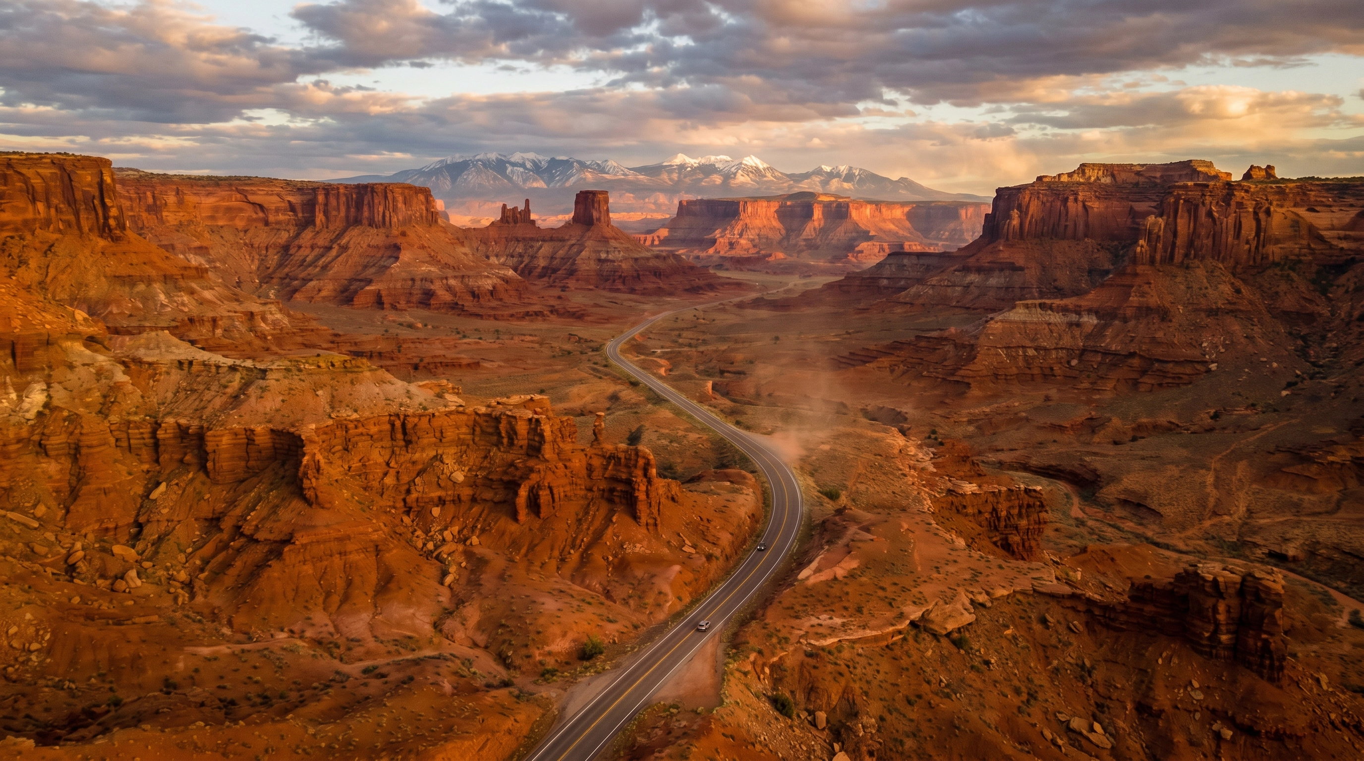
Day 6–7: Canyonlands — The Park That Puts Everything in Perspective
Drive 2.5 hours east to Moab, Utah — the adventure capital of the American West and your base for the next two days. Moab is a town that has figured out exactly what it is: a place where people come to feel small in the best possible way. The Colorado River runs through it. Red rock walls rise on every side. The coffee at Moab Coffee Roasters is genuinely excellent.
Canyonlands National Park is divided into four districts. The Island in the Sky district, 32 miles north of Moab, is the one you want for a first visit. It sits on a mesa 1,000 feet above the confluence of the Green and Colorado Rivers, and the views from the rim are the kind that make you question your entire understanding of scale.
Mesa Arch is the most photographed spot in Canyonlands, and the reason is simple: at sunrise, the arch frames the canyon below and the underside of the arch glows orange-red as the first light hits the rock beneath it. The effect lasts about 15 minutes. Get there 45 minutes before sunrise — photographers have been known to arrive hours early to claim their spot, and the parking lot fills fast. The hike is half a mile round trip on flat ground. The payoff is extraordinary.
Grand View Point Overlook is the end of the paved road and the best place to understand what the Colorado Plateau actually is. You're standing at the edge of a mesa looking out over 5,000 square miles of canyon country. The silence is total. On a clear day you can see the La Sal Mountains, the Henry Mountains, and canyon systems that stretch to the horizon in every direction. There is no railing. There is no interpretive sign that adequately explains what you're looking at. You just stand there and let it happen.
For the second day, consider the White Rim Road if you have a high-clearance 4WD vehicle — it's a 100-mile dirt road that circumnavigates the Island in the Sky mesa and is one of the great off-road drives in North America. If you're in a standard rental car, the Needles District (45 miles south of Moab) offers a completely different landscape of red and white banded spires and excellent hiking without the crowds of Island in the Sky.
For a deeper dive into Canyonlands — including the Needles District, the Maze, and the best overnight options in Moab — our 3-day Canyonlands adventure guide has everything you need.
Day 8–9: Arches — The Postcard That Doesn't Do It Justice
Arches National Park sits five miles north of Moab and contains over 2,000 natural stone arches — more than anywhere else on Earth. The park is compact (76,000 acres) and the main road is paved, which means it gets crowded. Timed entry reservations are required from April through October. Book them the moment they open (recreation.gov, 30 days in advance). They sell out within minutes.
Delicate Arch is the one on the Utah license plate and the one that every person who has ever seen a photo of Utah has seen. It's a 3-mile round-trip hike across open slickrock with no shade and significant exposure — start before 7 AM in summer, bring more water than you think you need, and wear sun protection. The arch itself is 52 feet tall and stands at the edge of a natural amphitheater with the La Sal Mountains behind it. At sunrise, the arch turns from pale orange to deep red over the course of about 20 minutes. At sunset, the same thing happens in reverse. Both are worth the hike. Both are genuinely moving in a way that's hard to articulate.
The Windows Section is where most people go when they don't want to hike Delicate Arch, and it's legitimately spectacular. North Window, South Window, and Turret Arch are all within a short walk of the parking area. The Double Arch — two arches that share a common base — is the largest arch in the park and one of the most dramatic geological formations you'll see anywhere.
The insider move at Arches is Landscape Arch, in the Devils Garden area at the end of the park road. It's the longest natural arch in North America — 306 feet from base to base — and it's genuinely terrifying. The arch is so thin in the middle (only 6 feet thick at its narrowest point) that large sections have collapsed in recent decades. You can see the debris on the ground below it. Standing underneath it and looking up is one of those experiences that makes you acutely aware of time in a way that very few things do.
Our 4-day Arches National Park adventure guide goes deeper on every trail, the best photography windows, and how to combine Arches with Canyonlands for a seamless Moab basecamp experience.
Day 10: The Drive Back to Las Vegas
The 4.5-hour drive back to Las Vegas on I-15 south passes through the Virgin River Gorge — a stretch of interstate that cuts through a canyon so dramatic that even seasoned road-trippers slow down to look. Stop in St. George, Utah for breakfast at Bear Paw Café (the French toast is the move). Stop at the Valley of Fire State Park in Nevada if you have an extra hour — it's 40,000 acres of Aztec sandstone formations that look like a scaled-down version of everything you've just spent ten days seeing, and it costs $10 to enter.
Get back to Las Vegas with enough time to decompress, eat something that isn't trail mix, and sit with what you just did. The city will feel surreal after ten days in the desert. That's normal. That's the point.
The Practical Details Nobody Puts in the Headline
Permits and reservations: Zion's Angels Landing requires a permit (recreation.gov lottery). Arches requires timed entry reservations (April–October). Wave permits at Coyote Buttes North are a separate lottery entirely. Book everything the moment the reservation window opens — typically 30 days in advance at midnight Mountain Time.
Best time to go: Mid-September through late October is the sweet spot. The summer crowds have thinned, temperatures are manageable (Zion in July can hit 105°F in the canyon), the light is golden, and accommodation prices drop. Spring (April–May) is equally beautiful but more crowded. Winter is genuinely spectacular — Bryce Canyon's hoodoos with a dusting of snow is one of the most surreal landscapes in America — but some facilities close and roads can ice over.
What to drive: A standard sedan handles all the paved roads on this itinerary. If you want to add the White Rim Road in Canyonlands or any of the dirt roads in Grand Staircase-Escalante, rent a high-clearance 4WD. Moab has several local rental companies that specialize in exactly this.
Where to stay: Book lodging in Springdale (Zion), Bryce Canyon City or Tropic (Bryce), Torrey (Capitol Reef), and Moab (Canyonlands/Arches) at least 4–6 months in advance for peak season. Camping inside the parks is magical but sells out even faster than hotels. The NPS campground at Devils Garden in Arches books out within seconds of opening.
The America the Beautiful Pass: $80 at any park entrance or online. Covers all five parks on this itinerary plus every other federal recreation site in the country for 12 months. It pays for itself on day one.
One Last Thing
There's a reason this road trip has become the defining American adventure for a generation of travelers who grew up thinking the best trips were on other continents. The American West is genuinely, staggeringly beautiful in a way that photographs don't capture and words don't fully reach. The scale is different here. The silence is different. The feeling of standing at the edge of something ancient and enormous and completely indifferent to your presence — that's different too.
Ten days is enough to see it. It's not enough to understand it. Most people who do this trip start planning the return trip somewhere around day three.
That's the right response.
Ready to build your American West itinerary? Leif puts together the full day-by-day plan — hikes, accommodation, driving times, and all the permits you need to book — in about 60 seconds.