Luang Prabang Is a City Built on Two Rivers. One of Them Is Disappearing.
Destination: Luang Prabang, Laos
Category: destination
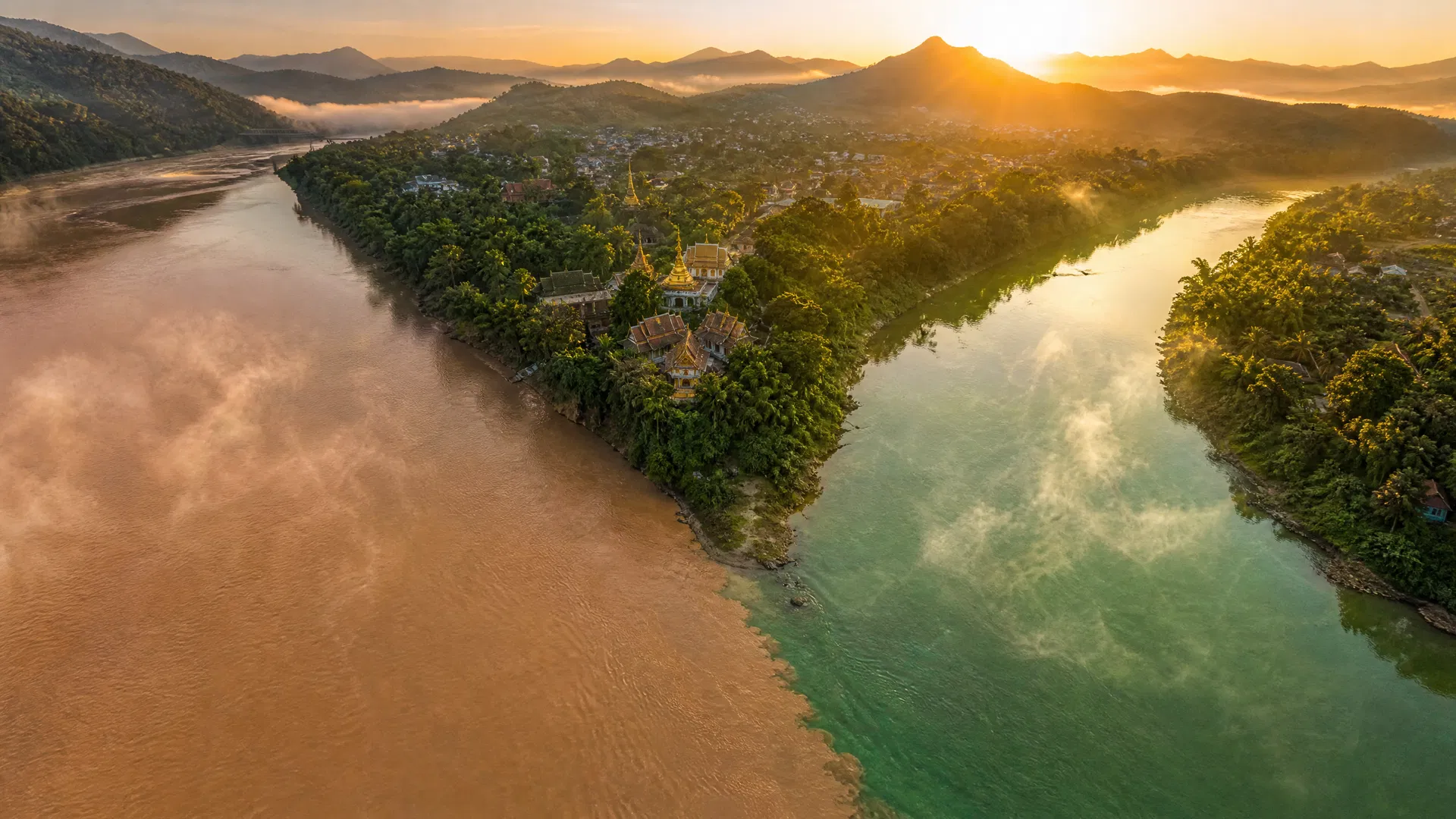
At dawn, before the tourist day begins, you can stand at the tip of the peninsula where the Mekong and the Nam Khan converge and watch the two rivers meet. They don't mix immediately. For a stretch of fifty meters or more, you can see the boundary — the Mekong running brown and heavy with sediment from somewhere upstream, the Nam Khan running clearer, greener, carrying the cooler water of the mountains to the north. The line between them is visible. The older residents of Luang Prabang say the Mekong used to run clearer. That the brown came later. That the sediment is heavier now than it was when they were children, and heavier in the dry season than it used to be, and that the fish they catch from it are different fish than the ones their fathers caught.
This is not a metaphor. The Mekong is changing. The change is measurable, documented, and ongoing. And Luang Prabang — which exists because of this river, which was built on this peninsula because of this river, which has organized its spiritual life and its food and its daily rhythms around this river for six hundred years — is in the middle of something that no travel guide will tell you about.
The city is a UNESCO World Heritage Site. It is also 25 kilometers downstream from a dam under construction. The Luang Prabang Hydropower Project, a 1,460-megawatt facility built by a Thai developer on a site that UNESCO's own monitoring mission described as a threat to the "authenticity and integrity" of the heritage site, began construction in 2023. The Lao government ignored UNESCO's recommendation to relocate the project. The dam is being built. The river is already different from what it was. The city that the river made is still here, still extraordinary, still one of the most genuinely affecting places in Southeast Asia — but the window for experiencing it as it has always been is narrowing in a way that is specific and real and not the kind of thing that travel writing usually says out loud.
Go now. That is the thesis. Everything else in this post is the evidence.
The Confluence That Made a Capital
The Lao kings did not choose this peninsula by accident. The confluence of two rivers in the mountainous north of Laos created something rare: a naturally defensible position with access to two separate water systems, surrounded on three sides by water, with the sacred Mount Phousi rising from its center like a geographic argument for divine favor. The city that grew on this peninsula became Luang Prabang — "the great sacred Buddha image" — named for the Phra Bang, a gold Buddha statue that the kings of Laos considered the palladium of the kingdom, the object whose presence guaranteed the city's protection.
The peninsula is small. You can walk its length in twenty minutes and its width in five. There are no tall buildings, no traffic lights, no chain restaurants. The French colonial architecture — the shuttered facades, the bougainvillea-draped walls, the wide verandas — sits alongside Lao temple complexes with the kind of visual coherence that UNESCO protects because it is genuinely rare. The streets are narrow enough that bicycles are the practical choice over tuk-tuks. The pace of the city is not a marketing decision. It is a physical consequence of the geography. The peninsula enforces slowness. There is nowhere to rush to that isn't already close.
The Mekong runs along the western and southern edges of the peninsula. The Nam Khan runs along the eastern and northern edges. The two rivers define the city's shape the way a riverbank defines a sandbar — the city exists in the space the rivers allow. Understanding this is not academic. It explains why the best restaurants are where they are, why the morning market is where it is, why the temples face the directions they face, and why the tak bat ceremony happens on the streets it happens on. The city's entire logic is a response to the rivers.
What the Mekong Remembers
The Mekong is the twelfth longest river in the world and one of the most biodiverse river systems on earth. It runs 4,350 kilometers from the Tibetan Plateau through China, Myanmar, Laos, Thailand, Cambodia, and Vietnam before reaching the South China Sea. For most of that distance, it has run free. In the section that passes Luang Prabang, it has run free for all of recorded history.
That is changing.
The Xayaburi dam, 130 kilometers downstream, was completed in 2019. Its reservoir backs up 20 kilometers upstream from the UNESCO site, which means that the stretch of river that passes the Luang Prabang waterfront is no longer a free-flowing river in the traditional sense — it is the tail end of a reservoir. The water moves differently. The sediment load has changed. The seasonal fluctuations that the city's fishermen used to predict by memory — the high-water months of July and August when the Mekong would rise to specific marks on the riverbank, the low-water months of February and March when the sandbars appeared and the fishing was best — no longer follow the patterns that the older fishermen remember.
The fishermen are still there. You can see them in the early morning, working the stretch of river below the Mekong waterfront restaurants, using the same techniques their fathers used. But the catch is different. The giant Mekong catfish — the pla buk, one of the largest freshwater fish in the world, which can reach three meters in length and 300 kilograms — used to migrate through this stretch of the Mekong on its annual journey from the delta to the upper reaches. The Xayaburi dam blocked that migration route. The pla buk no longer passes Luang Prabang. The fishermen catch smaller fish now, and fewer of them, and the fish they catch are different species than the ones that defined the city's food culture for centuries.
The Mekong's brown color — the sediment that the older residents say is heavier now than it used to be — is a direct consequence of upstream dam operations. The dams trap sediment in their reservoirs rather than allowing it to flow downstream, which means the riverbed below the dams is being scoured clean while the water runs clearer in some seasons and murkier in others depending on dam release schedules rather than natural rainfall patterns. The river that the Lao kings built a capital beside is not the same river. The change is visible. The change is measurable. The change is ongoing.
The Nam Khan Counter-Argument
The Nam Khan is the smaller river. It runs along the northern and eastern edges of the peninsula, fed by the mountains of northern Laos, and it has not yet been dammed in the section that passes Luang Prabang. It runs clearer than the Mekong. It runs cooler. In the dry season, when the Mekong is at its lowest and the sandbars appear, the Nam Khan is still moving with the energy of mountain water.
The eastern bank of the Nam Khan — across the bamboo bridge that locals use and most tourists don't — is a different Luang Prabang from the one on the UNESCO peninsula. The restaurants are quieter. The prices are lower. The people eating in them are more likely to be Lao than foreign. Dyen Sabai, the restaurant that sits on a wooden platform over the Nam Khan itself, serves or lam — the signature stew of Luang Prabang — made with mai sakahn, a wood chili vine that grows only in the mountains of northern Laos. The stew is thick and dark and carries a specific numbing heat from the mai sakahn that is unlike any chili heat you've encountered elsewhere. The pork stew version, which is what Dyen Sabai is known for, uses the mai sakahn wood itself as an ingredient — you eat around the chunks of wood the way you eat around a bay leaf, except the wood has been doing the work of flavoring the broth for hours before it reaches your bowl.
This dish does not appear in the top five Google results for Luang Prabang. It is not on any "best of" list that a casual traveler would encounter. It is what people who have actually been to Luang Prabang tell you to eat when you ask them what you shouldn't miss. The distinction matters because or lam is not just a dish — it is a direct product of the river culture. The herbs in the stew come from the riverbanks. The fish version uses Mekong fish. The wood comes from the mountains that feed the Nam Khan. The dish is the thesis made edible: Luang Prabang's identity is inseparable from its rivers, and the food is the most direct evidence.
The bamboo bridge that crosses the Nam Khan to reach Dyen Sabai is rebuilt every dry season and washed away every wet season. The river decides when you can cross. That is not a metaphor either.
The Morning Before the Tourists Arrive
Luang Prabang at 5:30 in the morning is a different city from Luang Prabang at 9:00 in the morning. The difference is not just the light, though the light is extraordinary — the way the mist sits on the Mekong in the cool season, the way the temple rooflines emerge from it as the sun comes up over the mountains to the east. The difference is who is in the streets.
The tak bat — the alms-giving ceremony in which Buddhist monks walk the streets of the old town at dawn to receive sticky rice from laypeople — has become one of the most photographed events in Southeast Asia. It is also, by the account of most honest observers, one of the most compromised. The monks walk. The tourists line the streets with cameras. The sticky rice that vendors sell to tourists for participation in the ceremony is often low-quality and sometimes rejected by the monks, who have been photographed dumping it in trash cans at the end of the route. Children collect the discarded offerings from the street. The ceremony continues because the monks continue it — it is a genuine religious practice, not a performance — but the context in which it happens has been so thoroughly altered by tourism that participating in it as a tourist is more likely to harm the practice than honor it.
What to do instead: walk the residential streets around Wat Xieng Thong at 5:30am, before the tourist route begins. The monks walk here too. The locals giving alms here are giving because they believe in the merit it generates, not because a tour operator positioned them on the street. The ceremony is quieter. The light is the same. You are not in anyone's photograph. You are not a participant in the spectacle. You are a person watching a city do what it has always done, before the day begins.
After the walk, go to Saffron Coffee. It opens at 7am. The beans are Arabica from the Bolaven Plateau in southern Laos — the same high-altitude plateau that produces some of the best coffee in Southeast Asia — and they are roasted weekly in Luang Prabang, not shipped in from elsewhere. The roasting schedule means the coffee you drink at Saffron is never more than a week old. The café is small and the seating spills onto the street and the street faces the Mekong. The 7am-to-9am window, before the tour groups arrive and the street fills with the sound of tuk-tuks and the smell of sunscreen, is the best two hours Luang Prabang offers. Drink the coffee slowly. Watch the river. The fishermen are still out.
The morning market, which runs from 5am to 8am on the main street of the old town, is the other reason to be awake before the tourist day begins. It is not a tourist market. It sells the ingredients that the city's restaurants and households use: river algae dried into sheets and seasoned with sesame, wild mushrooms from the surrounding mountains, live frogs, bundles of herbs that include the mai sakahn vine that goes into or lam, grilled river fish wrapped in banana leaves, and khao niew — the sticky rice that is the staple of Lao cuisine, eaten with every meal, carried in small woven baskets by monks and schoolchildren and office workers alike. The market is gone by 8am. If you arrive at 9am, you have missed it.
The Food That Comes From the Water
Luang Prabang's food culture is inseparable from its rivers in a way that is more literal than the phrase usually implies. The Mekong produces the fish. The riverbanks produce the herbs. The mountains that feed the Nam Khan produce the mai sakahn wood. The food is a direct map of the geography.
Khao soi at Luang Prabang is not the khao soi you know from Chiang Mai. The Thai version is a coconut curry with egg noodles. The Luang Prabang version is a tomatoey, minced-pork soup with soft rice noodles and a pile of fresh herbs — lighter, more acidic, built around the tomato rather than the coconut. The stall across from Wat Sensoukharam, known locally as Khao Soi Wat Sen, is the version that the city's food community points to when they want to show a visitor what the dish actually is. A bowl costs less than two dollars. It is served from 7am until it sells out, which is usually before 10am. The herbs on top — sawtooth coriander, green onion, fresh chili — come from the morning market.
The jaew kee pa — a chili dip made with fish eggs — is the other dish that defines what Luang Prabang tastes like. Xieng Thong Phonsavahn Restaurant, at the end of the peninsula where the Mekong and Nam Khan converge, serves the version that the restaurant's owner has described as the dish you haven't eaten until you've been to Luang Prabang. The fish eggs come from the Mekong. The chili comes from the surrounding mountains. The dish is the confluence made edible.
The night food street — the alley that runs perpendicular to the souvenir night market — is where the Lao stew stalls are. The vegetarian buffets are cheap and greasy and aimed at tourists. The stalls worth finding are the ones selling or lam and or bon (taro leaf stew) and the grilled Mekong fish wrapped in banana leaves. The fish is caught the same day. The banana leaves are from the riverbanks. The charcoal is from the mountains. The entire supply chain is local in a way that most cities in Southeast Asia can no longer claim.
The Textiles of the North
Ock Pop Tok — "East Meets West" in Lao — sits on the Mekong riverside about two kilometers from the old town center. It is a living crafts centre, not a museum, and the distinction matters. The weavers are working. The looms are running. The silk being dyed in the courtyard is being dyed with natural pigments — indigo, jackfruit wood, teak leaves — using techniques that the five ethnic groups represented in the Village Weavers Project have been using for generations.
Those five groups are the Oma, the Katu, the Hmong, the Tai Muang, and the Tai Daeng. Each has a room in the centre dedicated to their specific textile traditions. The Hmong room shows the reverse appliqué and batik techniques that produce the geometric patterns on Hmong clothing. The Tai Daeng room shows the supplementary weft weaving that produces the intricate patterns in Tai Daeng silk. The guided tours are free. The guides know the specific techniques and the specific villages and the specific weavers whose work is on display.
The shop at the end of the tour sells the textiles at prices that reflect what they actually cost to make. A hand-woven silk scarf that took a weaver three days to produce costs what a hand-woven silk scarf that took a weaver three days to produce should cost. This is not a bargaining situation. The price is the price because the price is honest.
The Mekong is visible from the weaving courtyard. The silk drying on the racks moves in the river breeze. The connection between the river and the textiles is not decorative — the natural dye plants grow along the riverbanks, and the water used in the dyeing process comes from the river. The textiles are another product of the confluence. If you want to build a trip around the specific rhythm of the city — the morning market timing, the Saffron Coffee window, the Dyen Sabai dinner — the Luang Prabang for Couples: A 4-Day Romantic Escape to Laos' Ancient Capital builds exactly that structure.
When to Go, Getting Around, Getting There
When to go: The cool dry season — November through February — is when Luang Prabang is at its most comfortable and most photogenic. Temperatures are 15–25°C, the mist sits on the rivers in the morning, and the light has the quality that photographers describe as golden without meaning it as a cliché. The hot season (March–May) is genuinely hot — 35°C or above — and the rivers are at their lowest, which means the sandbars appear and the fishing is best but the walking is punishing. The wet season (June–October) brings the Mekong to its highest levels and the surrounding mountains to their most intensely green, but also brings the humidity and the afternoon downpours that make outdoor activities difficult.
The China-Laos railway, which opened in 2021, made Luang Prabang accessible in a way it never was before. The journey from Vientiane takes 2 hours by train (it used to take 10 hours by bus). From Kunming in China, the journey takes 10 hours. Tickets within Laos cost $15–25 depending on class. The LCR Ticket app (Android and iOS) is the most reliable booking method — note that tickets are only available up to one week in advance and require a Laos, China, Thailand, or Vietnam phone number to book.
The two-day slow boat from the Thai border at Chiang Khong to Luang Prabang, drifting down the Mekong past villages and mountains and sandbanks, is still one of the most genuinely immersive ways to arrive. The river you arrive on is the river the city is built around. The arrival makes sense in a way that arriving by plane does not.
Getting around: The peninsula is walkable. Bicycles are available for rent everywhere and are the right choice for reaching the Ock Pop Tok centre and the Nam Khan eastern bank. Tuk-tuks (called jumbos in Luang Prabang) are necessary for Kuang Si Falls and Pak Ou Caves. Negotiate the price before you get in.
Planning Your Luang Prabang Trip
Four days is the minimum for Luang Prabang done properly. Three days leaves you feeling like you arrived just as the city was beginning to make sense. Five days is better. The city rewards the traveler who stays long enough to develop a routine — the same coffee stall in the morning, the same stretch of Mekong at sunset, the same walk across the bamboo bridge to the Nam Khan side for dinner.
The couples guide to Luang Prabang builds the four-day structure around the specific rhythm of the city: early mornings on the peninsula, midday at the temples or Ock Pop Tok, afternoons on the Nam Khan side, evenings on the Mekong waterfront. The itinerary accounts for the morning market timing, the Saffron Coffee window, and the Dyen Sabai dinner reservation that is harder to get than it should be for a restaurant on a bamboo platform over a river.
If you're building the trip yourself, the AskLeif itinerary generator will build it around your specific dates, budget, and travel style — accounting for the seasonal river conditions, the morning market hours, and the specific experiences that are worth the early alarm.
The one practical note that no guide emphasizes enough: the bamboo bridge to the Nam Khan eastern bank costs 10,000 kip (less than a dollar) to cross and is only open during the dry season. If you're traveling in the wet season, you cross by boat. Either way, cross it. The eastern bank is where the city that the tourists haven't found yet is still operating.
The Dam and the Urgency
The Luang Prabang Hydropower Project is 25 kilometers upstream from the UNESCO heritage site. Construction began in 2023. UNESCO's 2022 monitoring report recommended that the Lao government "take the precautionary approach, not to pursue the LPHP, and relocate the project." The government ignored the recommendation. The Thai developer — CK Power, a subsidiary of Bangkok-based Ch.Karnchang — continued construction. Thailand signed a power purchase agreement for the electricity the dam will generate, despite the fact that Thailand already has an electricity reserve margin more than double the international norm.
The dam is being built because the money is there and the political will to stop it is not. That is the honest summary.
What the dam will do to Luang Prabang is not fully known. What is known: the reservoir will extend upstream from the dam site, altering the river's behavior in the stretch that passes the city. The sediment load will change further. The seasonal patterns that the city's fishermen and farmers and temple gardeners have organized their lives around will change further. The Mekong that the Lao kings chose as the western boundary of their capital will be a different river from the one they chose.
The city will still be there. The temples will still be there. The morning market will still be there. The or lam at Dyen Sabai will still be there, as long as the mai sakahn vine still grows in the mountains that feed the Nam Khan. But the specific character of the place — the quality of the light on the water, the behavior of the river at dawn, the fish in the market, the sound of the current under the bamboo bridge — is in the process of changing in ways that are not reversible.
The older residents of Luang Prabang remember the Mekong differently from how it is now. Their children will remember it differently from how it is now. The city at the confluence of two rivers is still one of the most genuinely extraordinary places in Southeast Asia. The window for experiencing it as the rivers made it is narrowing.
The photographs will not prepare you. The river is still there. Go while it is.